Located in the department of Lom-et-Djerem, in the East region, the municipality of Garoua-Boulaï is a decentralized local authority whose administrative organization is part of the territorial reforms undertaken by the Cameroonian government since the 1970s. The territory is gradually being structured into districts and then municipalities in accordance with laws on municipal organization and decentralization, making Garoua-Boulaï an entity responsible for managing local development and coordinating public actions at the territorial level.
It covers an area of approximately 1,200 km² and has an estimated population of over 80,000 inhabitants, spread across several neighborhoods and villages organized around traditional chiefdoms recognized by the administration.
Located in the eastern part of the East Region, near the border with the Central African Republic, the municipality of Garoua-Boulaï occupies a strategic position in cross-border economic exchanges and the movement of people and goods. It is an important transit point and a major commercial hub between Cameroon and the Central African Republic. It is characterized by great sociocultural diversity, including the Gbaya, Fulani, Hausa, and other groups from different regions, who actively participate in the local social and economic dynamic.
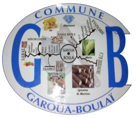
The local economy is based mainly on agro-pastoral activities, cross-border trade, transport, and services, supported by a gradually improving network of socio-educational, health, and commercial infrastructure.
As part of efforts to strengthen territorial governance and decentralization, the municipality of Garoua-Boulaï has undergone various administrative reorganizations aimed at bringing the administration closer to the people and optimizing the management of local public services.
Thanks to its strategic location, significant economic potential, and the commitment of its local stakeholders, Garoua-Boulaï is now positioned as a dynamic and rapidly evolving territory, engaged in a process of participatory governance and resource development in the service of sustainable local development.
Population
Total area/km²
Year of Creation
Neighbourhoods & Villages
Health areas
Primary Schools
The municipality of Garoua-Boulaï covers a vast area of approximately 1,200 km² in the eastern part of the East Region. It is located close to the border with the Central African Republic, which gives it strategic importance in cross-border trade and the movement of people and goods between the two countries.
The terrain consists mainly of plains and gently rolling hills, interspersed with seasonal watercourses, which are favorable for agricultural and pastoral activities. The climate is tropical and humid, characterized by a relatively long rainy season and a moderate dry season, conditions conducive to food crops, small-scale livestock farming, and commercial activities related to local production.
The territorial organization of the municipality is based on several villages and neighborhoods structured around recognized traditional authorities, forming a coherent administrative and community network. This structure facilitates local governance and the implementation of development actions for the benefit of the population.
The administrative history of the municipality of Garoua-Boulaï is closely linked to the various territorial reforms that took place in Cameroon after independence, as part of efforts to strengthen territorial administration and decentralization. Located at a strategic point on the border with the Central African Republic, Garoua-Boulaï has gradually established itself as a major administrative and commercial center in the eastern part of the country.
Through a series of administrative reorganizations, the territory was established as an arrondissement, confirming its strategic role in the Lom-et-Djerem Department. The creation of the municipality of Garoua-Boulaï was part of decentralization policies aimed at giving local authorities management autonomy, with the mission of planning and implementing municipal development actions as close as possible to the population.
With the evolution of the legal framework for decentralization, particularly through various laws on the organization of decentralized local authorities, the municipality has seen its powers gradually strengthened in the areas of local infrastructure management, economic development, social action, and land use planning.
This administrative change marks the various stages in the strengthening of local governance in Garoua-Boulaï, reflecting the government’s desire to consolidate local administration and optimize the management of local authorities in the Lom-et-Djerem Department.
The population of the municipality of Garoua-Boulaï is estimated at over 141,388 inhabitants. It is characterized by great ethnic and cultural diversity, including the Gbaya, Fulani, Hausa, and other groups from the Sahelian and Central African regions. This socio-cultural richness is an asset for social cohesion and promotes the harmonious coexistence of traditions within the municipality.
The economic activities of the inhabitants are mainly focused on subsistence and commercial agriculture, livestock farming, cross-border trade, and local crafts. Local culture is expressed through vernacular languages, customary practices, traditional chiefdoms, and cultural events that punctuate community life. Solidarity, mutual aid, and respect for traditional authorities remain central values in the social organization and community functioning of Garoua-Boulaï.